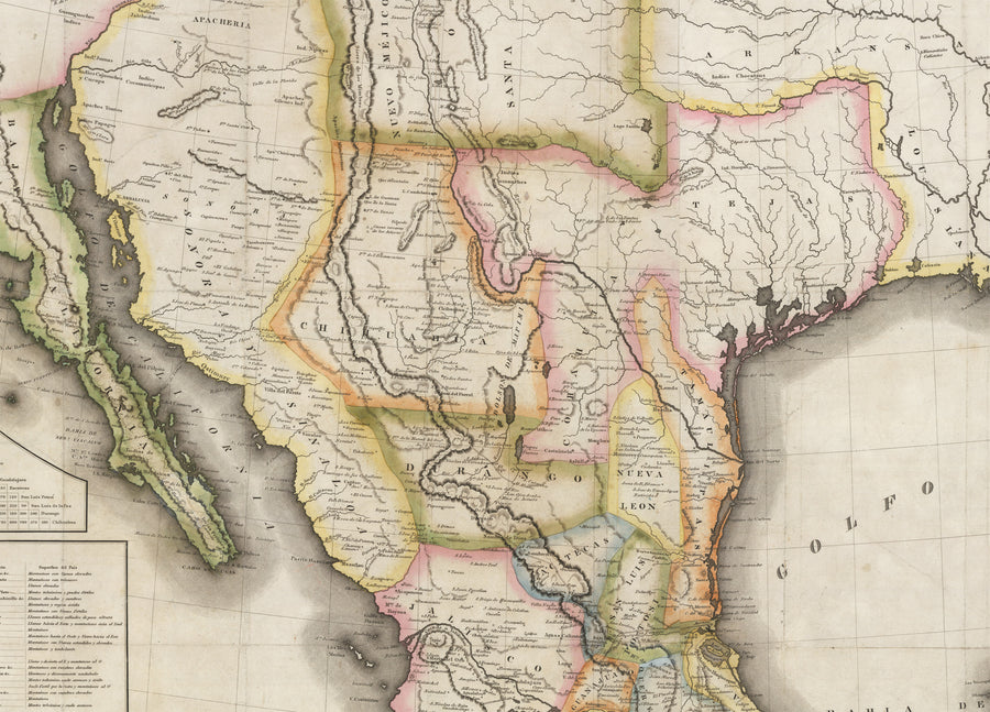
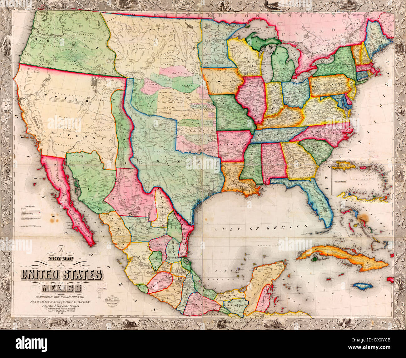
Mappa de los Estados Unidos de Mejico
A fine print reproduction of The "Treaty Map of the Mexican-American War." - Treaty of Guadaloupe Hidalgo, Mexican-American War
Mappa de los Estados Unidos de Mejico, segun lo organazido y definido por las varias actas del Congreso de dicha Republica y construido por las mejores autoridades.
By: White, Gallaher, & White
Date of Original: 1828 (dated ) New York
Original Size: 41 x 29 inches (104 x 71 cm)
This is a fine print reproduction of a rare first edition map (in Spanish) of what would be known as the Treaty Map of the Mexican-American War. This map would prove to be an instrumental piece to the Treaty of Guadaloupe Hidalgo and is the first in a series of maps to define the border between Mexico and the United States of America.
This fascinating map presents all of Mexico when it was at it's greatest size. Much of the land north and to the west of the Rio Grande however would fall under conflict between the Texans and Unites States in the coming decades, ultimately reducing the size of Mexico by nearly half. The War of Texas Independence, would be fought from October 1835 to April 1836. and the Mexican-American War would follow just a decade later from April 25, 1846 to February 2, 1848. A later reprinting of this map (wqith some notable changes) by John Distrunell would be utilized during the Treaty of Guadaloupe Hidalgo, signed on February 2, 1848, ending the Mexican-American War. This map is considered among collectors and scholars as the first of a series of maps that would ultimately define the border between Mexico and the United States.
Early routes of trade, commerce, and emigration such as the Santa Fe Trail, and El Camino Real are delineated within the map, connecting both Mexico City, and the western-most outpost of the United States (Fort Osage) to the historic and pivotal town of Santa Fe. Locations of numerous Native American tribes are found throughout the map, including the Apaches and Navajos, both of which had been at war with first the Spanish Conquistadores, and then the Mexicans for centuries.
Texas is shown in its pre-revolution state at a time when there were only a few thousand Americans that had settled there. After the Mexican Revolution of 1824, the Mexican government needed settlers to protect it from foreign invasion, and they offered liberal land grants to anyone who would become citizens and accept the Catholic faith. Eventually, American immigrants in Texas outnumbered the Mexicans and a series of events led to the Texan Revolution. In this map, the only town of significance is San Antonio.
The cartography of Alta California features numerous cartographic errors including the overall delineation of the coastline, and two large rivers that appear to be sourced from major inland lakes, one of which is in the place of the Great Salt Lake. There is no representation of the Sierra Nevada Mountains or the Grand Canyon, nor would there be until the latter half of the 19th Century.
The lower left portions of the map features an extensive table of distances, a table of statistics that includes the population, size (in square miles) and a geographical description of each state in Mexico. Just below these tables is an inset map titled Carta de los Caminos &c. Desde Vera Cruz y Alvarado a Mejico, which as the title suggests, shows the major roads between Mexico City and Vera Cruz on the gulf coast. This is a centuries-old network of roads dating back to and arguably before the arrival of Hernán Cortés in 1521.
Inventory #11909

Mapa Dos Estados Unidos E México. Vetor Royalty Free SVG, Cliparts, Vetores, e Ilustrações Stock. Image 75208462

Mapas de México y sus características - escuela de mapas
Ilustración vectorial - mapa de Estados Unidos Mexicanos Vector de stock por ©pavalena 5752455

Mapas de Mexico.pdf

MAP--MEXICO & TEXAS] DISTURNELL, JOHN. Mapa de los Estados Unidos de Mejico. New York: J. Disturnell, 1847. Stated Revise - Price Estimate: $15000 - $25000

Mapa Do Vetor De Estados Unidos Do Mexicano Ilustração do Vetor - Ilustração de beira, curso: 121446484

Vector Mão Desenhada Mapa Estilizado Dos Estados Do México. Ilustração De Viagem. A Ilustração Da Geografia Dos Estados Unidos Mexicanos. Elementos Do Mapa Da América Latina Royalty Free SVG, Cliparts, Vetores, e
CENAM
Mappa de los Estados Unidos de Mejico Fine Print Reproduction – the Vintage Map Shop, Inc.

Mapa pictórico de México 1938. Mapa de los Estados Unidos Mexicanos. Vintage home Deco Style antigua reproducción de la pared del mapa impreso. - España

La frontera entre México y EEUU
c8.alamy.com/compes/dx0ycb/nuevo-mapa-de-los-estad
Mapa fisico de nuevo mexico fotografías e imágenes de alta resolución - Alamy
1948 Revised Copy. The map shows INDIAN TERRITORY where Kansas and Oklahoma are now located. It is in Very Good condition. A 2 tear along the left

LARGE MAP - MAPA de los Estados Unidos de Mexico - 1948 Copy - (42 x 30)

Map of Mexico, Mapa De Los Estados Unidos De Méjico, 1847. Vintage Restoration Hardware Home Deco Style Old Wall Reproduction Map Print.